
Urban Growth Boundary Policies: A Balancing Act between New Development and the Preservation of Agricultural Land and Open Space
Part 1 (Series that examines urban growth boundaries)
November 14, 2025
By Justin Gallagher
 Source: iStock credit Tashka
Cities with growing populations often face a tension between meeting housing demand
and land conservation objectives, such as the preservation of productive agricultural
and forestland, wilderness areas, and other forms of open space. Regulation that reduces
the supply of new housing can lead to higher housing prices and lower economic growth.
Unchecked development can lead to sprawl-like development patterns that irreversibly
alter resource-dependent rural communities, increase pollution and traffic congestion,
and reduce the innovation that is typical of dense urban areas.
Nowhere is this tension more evident than in the northwestern US. Smaller cities in
the northwest are often surrounded by agricultural land and open space. Moreover,
seven of the ten fastest growing micropolitan areas (cities with less than fifty thousand
people) are in the northwest. In Montana, for example, over half of new home construction in recent years has taken place outside incorporated city
limits. This growth of new housing in rural areas has exacerbated the perception among
existing residents that housing expansion is undesirable due to its negative impacts on land preservation and rural economies.
Dr. Daniel Benjamin at Oregon State University and I are leading a multi-year research
initiative on urban growth boundaries. Urban growth boundaries (UGB) are a type of
local land use regulation that typically sets a boundary around an incorporated municipality.
New development outside of this boundary is restricted. The restrictions imposed on
development outside of the UGB can vary, but generally disallow large-scale housing
development, such as subdivisions. In most cases, UGBs can expand over time to accommodate
population growth. The expansion process is guided by local jurisdictional rules and
regulations. UGB policies have been adopted in the US states of Oregon, parts of Washington
and Tennessee, and localities in California, Colorado, and Florida. While the specific
rules and regulations vary from place to place, the broad aim of all UGB policies is to better manage future urban growth in areas surrounded by undeveloped land through
the promotion of denser patterns of land development.
A UGB policy is a potential tool to balance new development and the preservation of
agricultural land and open space, by steering new development closer to existing city
centers. UGB policies need not be a barrier to regional population and economic growth.
A growing population can be accommodated by new development within the UGB, provided
development with the UGB is fostered, and the boundaries are periodically expanded
as developable land within the UGB becomes scarce.
A criticism of UGB policies is that, in practice, these policies may lead to less
new development. This has (at least) two potentially negative consequences. First,
there may be fewer new houses built, leading to higher home prices. Second, if a UGB
policy acts a drag on population growth, then this can lead to a less-dynamic regional
economy with lower job and wage growth.
Our goal is to provide detailed, empirically-driven answers to a number of unanswered
questions related to UGBs. First, how do UGBs affect the spatial pattern of development
both immediately and after several decades? Second, do UGBs reduce the total amount of new development in a region? Third, how do UGBs affect house prices? Fourth,
do UGBs impact the amount of agricultural land in the vicinity of an urban area?
Our main study area is Oregon. There are number of reasons that make Oregon an almost
ideal testbed to study UGB policies in general, and to examine the impact an UGB policy
might have if adopted in Montana. A future blog post will go into depth on the details
of Oregon’s UGB policy.
As a first step in answering our list of UGB policy questions, we have (mostly) built
a new 75-year spatial database for the state of Oregon. This post concludes by highlighting
how the new database will allow us to carefully analyze the longer run impact of a
UGB policy.
Oregon’s UGB policy became law in 1980 and applies to all incorporated places (cities
and towns) in the state. Figure 1 depicts the state of Oregon and the location of
all 200-plus UGBs in red. The boxed insert highlights Medford’s UGB and shows how
the location of the boundary has expanded between 1980 and 2020.
Figure 1: Map of Oregon with Medford Highlighted
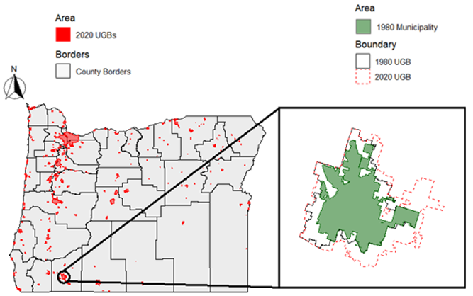
Data source: Oregon Department of Land Conservation and Development
We spatially link the UGB maps with plot-level development information. The entire
state is divided into 250 meter by 250 meter (approximately 15 acres) fixed land plots.
The plots are a way to grid up the land in the state, and do not correspond to political
boundaries or private ownership. Development is measured by tracking the year when
a new structure is built on each plot.
Figure 2 shows the number of buildings per plot in and around the Medford UGB for
the years 1945, 1980, and 2020. The darker green plots indicate more intense development.
The figure appears to show that most new development in the forty years between 1980,
the 1st year of the UGB policy, and 2020 occurred inside the UGB. The statistical models
we use in our analysis will seek to precisely pin down how the UGBs causally affected
new development. The models control for a host of confounding geographic factors,
including land covered by water (lakes, ponds, rivers, etc.), land slope and elevation,
public land, and soil quality.
Figure 2: Intensity of Land Development in Medford, OR
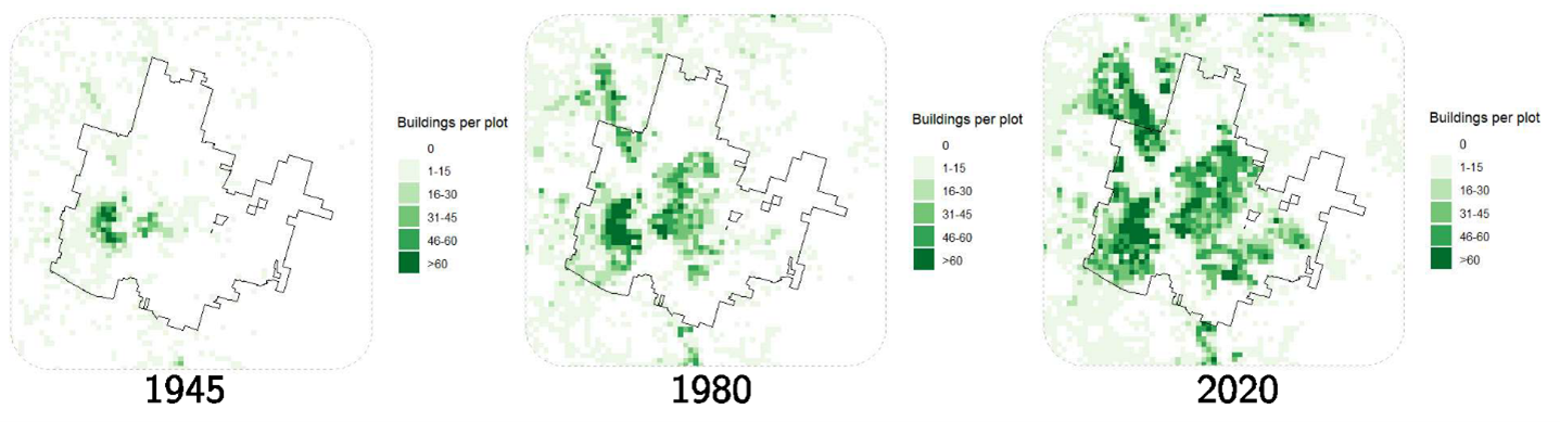
Data source: Historical Settlement Data Compilation of the United States (Ahn, Leyk, Uhl, and McShane, 2024)
The next blog post in this series will describe the Oregon UGB policy in detail. I
will also share what we’ve found regarding our first research question on how the
Oregon UGBs have affected the spatial pattern of development both immediately and
after four decades.
This is Part 1 of a Series that examines urban growth boundaries.

Justin Gallagher
Associate Professor
Montana State University is an ADA/EO/AA/Veteran’s Preference Employer and Provider of Educational and Outreach.